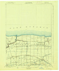
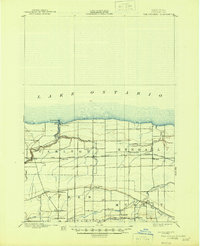
1897 Map of Oak Orchard
USGS Topo · Published 1938About this map
Point Breeze sits at the northern terminus of this Lake Ontario shoreline, where the Oak Orchard L. H. once guided vessels entering from the open water. This 1890s era survey captures a landscape defined by the parallel infrastructure of the Erie Canal in the south and the Rome Watertown and Ogdensburg R. R. across the midsection. Small hamlets like Hulberton and Hindsburg cluster along the canal, serving as vital transit points for the local agricultural economy. Further north, the Ridge Road provides a historic overland route through Gaines and East Gaines. The branching waterways of Oak Orchard Creek and Sandy Creek cut through the townships of Carlton, Kendall, and Murray, revealing a network of rural settlements including Sawyer, Kent, and West Kendall before they reached modern expansion.
Find a feature on this map
35 named features on this map. Tap any name to fly to it.
Don’t see what you’re looking for? This feature index may not catch every label — zoom into the map to look around manually.
Map Details
Editions of this 1897 Oak Orchard Map
6 editions found
Other maps of this area

1897 · Albion
USGS Topo · 1:62,500

1897 · Medina
USGS Topo · 1:62,500

1897 · Oak Orchard
USGS Topo · 1:62,500

1897 · Ridgeway
USGS Topo · 1:62,500

1899 · Hamlin
USGS Topo · 1:62,500

1899 · Brockport
USGS Topo · 1:62,500

1932 · Hamlin
USGS Topo · 1:24,000

1934 · Brockport
USGS Topo · 1:24,000

1935 · Hamlin
USGS Topo · 1:24,000

1944 · Holley
USGS Topo · 1:31,680