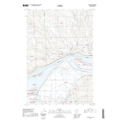
2020 Map of Oak Point
USGS Topo · Published 2020About this map
Oak Point and the nearby settlements of Quincy and Inglis anchor this riverside landscape along the Columbia River at the border of Washington and Oregon. The area is defined by a complex network of waterways including Oak Point Channel, Eureka Channel, and Gull Island Turn and Channel, which separate the mainland from substantial river features like Crims Island and Gull Island. Family and community history is preserved in numerous burial grounds across the hills and bottoms, such as Grasseth Cem, Bunker Hill Cem, and Stewart Hill Cem. The terrain rises toward Bunker Hill in the north, while the lowlands are webbed with drainage features like Pousky Slough, Bradbury Slough, and Beaver Slough. These interconnected sloughs and islands illustrate the historical importance of the river for navigation and agriculture in Cowlitz and Columbia counties.
Find a feature on this map
99 named features on this map. Tap any name to fly to it.
Don’t see what you’re looking for? This feature index may not catch every label — zoom into the map to look around manually.
Map Details
Editions of this 2020 Oak Point Map
This is the sole edition of this map. No revisions or reprints were ever made.
Other maps of this area

1919 · Mayger
USGS Topo · 1:62,500

1941 · Skamokawa
USGS Topo · 1:62,500

1941 · Clatskanie
USGS Topo · 1:62,500

1941 · Cathlamet
USGS Topo · 1:62,500

1952 · Clatskanie
USGS Topo · 1:62,500

1953 · Hoquiam
USGS Topo · 1:250,000

1953 · Ryderwood
USGS Topo · 1:62,500

1953 · Skamokawa
USGS Topo · 1:62,500

1953 · Cathlamet
USGS Topo · 1:62,500

1957 · Hoquiam
USGS Topo · 1:250,000