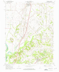
1974 Map of Oaktown
USGS Topo · Published 1975About this map
Oaktown serves as a northern anchor in this rural portion of Knox County, characterized by a transition from the broad, flat bottomlands of the Wabash River to the more dissected drainage basins of Busseron Creek and Maria Creek. The local economy of the mid-1970s is reflected in a landscape defined by agriculture and transport, with the Louisville And Nashville and Penn Central railroads cutting north-south and east-west through the terrain. Evidence of community history is preserved in several rural burial grounds including Light Cem and Threlkeld Cem, while the North Knox West Sch marks the educational center for the surrounding townships. Topographical features like Wolf Hill and Sevenmile Island illustrate the diverse riverine environment that shaped the settlement of nearby Emison and Bruceville.
Find a feature on this map
37 named features on this map. Tap any name to fly to it.
Don’t see what you’re looking for? This feature index may not catch every label — zoom into the map to look around manually.
Map Details
Editions of this 1974 Oaktown Map
2 editions found
Other maps of this area

1915 · Vincennes
USGS Topo · 1:62,500

1917 · Birds
USGS Topo · 1:62,500

1942 · Fritchton
USGS Topo · 1:24,000

1942 · Birds
USGS Topo · 1:62,500

1943 · Carlisle
USGS Topo · 1:24,000

1943 · Oaktown
USGS Topo · 1:24,000

1943 · Bicknell
USGS Topo · 1:24,000

1944 · Bucktown
USGS Topo · 1:24,000

1944 · Fritchton
USGS Topo · 1:24,000

1944 · Wheatland
USGS Topo · 1:24,000