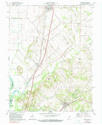
1974 Map of Oaktown
USGS Topo · Published 1984About this map
The settlement of Oaktown serves as a primary hub in the northern portion of this 1970s landscape, which is defined by the agricultural and riparian corridors of the Wabash River valley. The map documents a mature rural infrastructure where the Louisville and Nashville and Penn Central railroads intersect the landscape, connecting the smaller community of Emison and the village of Bruceville. Notable for genealogists and local historians, the sheet preserves the locations of numerous family-named burial grounds like Ocheltree Cem and Threlkeld Cem, alongside landmarks such as Camp Arthur and the Rod and Gun Club Lake. The terrain transitions from the alluvial plains near Sevenmile Island to the higher ground of Wolf Hill, with the complex drainage of Maria Creek and Busseron Creek shaping the development patterns of Washington and Busseron townships.
Find a feature on this map
35 named features on this map. Tap any name to fly to it.
Don’t see what you’re looking for? This feature index may not catch every label — zoom into the map to look around manually.
Map Details
Editions of this 1974 Oaktown Map
2 editions found
Other maps of this area

1915 · Vincennes
USGS Topo · 1:62,500

1917 · Birds
USGS Topo · 1:62,500

1942 · Fritchton
USGS Topo · 1:24,000

1942 · Birds
USGS Topo · 1:62,500

1943 · Carlisle
USGS Topo · 1:24,000

1943 · Oaktown
USGS Topo · 1:24,000

1943 · Bicknell
USGS Topo · 1:24,000

1944 · Bucktown
USGS Topo · 1:24,000

1944 · Fritchton
USGS Topo · 1:24,000

1944 · Wheatland
USGS Topo · 1:24,000