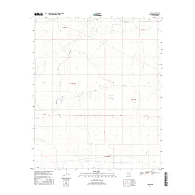
2017 Map of Oasis
USGS Topo · Published 2017About this map
Oasis serves as the central point of reference in this arid expanse of Chaves County, situated along the primary east-west corridor of 2nd ST. The landscape is defined by its water management infrastructure, where numerous named livestock tanks—essential for ranching in the high desert—dot the terrain. These features, such as Meadow Tanks, Claypit Tanks, and Beadle Tank, suggest a land use pattern dominated by open-range grazing. The grid-like road system is anchored by several local thoroughfares, including Quemado RD, Co RD 65, and Gato RD, which facilitate movement between the various townships and ranges. This 2017 survey captures the sparse but organized settlement pattern of the region, where individual named water sources like Red and White Tank and Duncan Tank function as vital landmarks for local navigation and agricultural history.
Find a feature on this map
22 named features on this map. Tap any name to fly to it.
Don’t see what you’re looking for? This feature index may not catch every label — zoom into the map to look around manually.
Map Details
Editions of this 2017 Oasis Map
This is the sole edition of this map. No revisions or reprints were ever made.
Other maps of this area
1949 · Sardine Mountain
USGS Topo · 1:24,000
1949 · Malstrom Ranch
USGS Topo · 1:24,000

1954 · Brownfield
USGS Topo · 1:250,000

1955 · Roswell
USGS Topo · 1:250,000

1958 · Brownfield
USGS Topo · 1:250,000

1958 · Roswell
USGS Topo · 1:250,000
1962 · Roswell
USGS Topo · 1:250,000

1962 · Brownfield
USGS Topo · 1:250,000
1967 · Sardine Lake
USGS Topo · 1:24,000
1973 · Culp Ranch
USGS Topo · 1:24,000