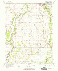
1968 Map of Oblong South
USGS Topo · Published 1970About this map
North Fork Embarras River winds through this rural landscape on the border of Jasper and Crawford County, defining a region shaped by agricultural persistence and the mid-century energy industry. While the town of Oblong sits at the northern edge, the map reveals a countryside punctuated by scattered civic and religious nodes, including the Yager Cem Townhall and small educational centers like Berlin Sch and Bend Sch.
Find a feature on this map
28 named features on this map. Tap any name to fly to it.
Don’t see what you’re looking for? This feature index may not catch every label — zoom into the map to look around manually.
Map Details
Editions of this 1968 Oblong South Map
2 editions found
Other maps of this area

1910 · Hardinville
USGS Topo · 1:62,500

1940 · Greenup
USGS Topo · 1:62,500

1941 · Newton
USGS Topo · 1:62,500

1943 · Greenup
USGS Topo · 1:62,500

1943 · Newton
USGS Topo · 1:62,500

1953 · Indianapolis
USGS Topo · 1:250,000

1956 · Indianapolis
USGS Topo · 1:250,000

1956 · Annapolis
USGS Topo · 1:62,500

1956 · Vincennes
USGS Topo · 1:250,000

1957 · Indianapolis
USGS Topo · 1:250,000