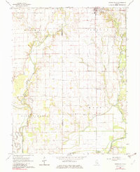
1968 Map of Oblong South
USGS Topo · Published 1982About this map
The southern outskirts of Oblong and the small hamlet of Pierceburg characterize this section of the Illinois prairie in the late 1960s. The landscape is a mix of agricultural fields and active energy extraction, noted by numerous Oil Wells and an extensive Oil Field dotting the countryside between the Embarras River and the North Fork. Local civic and religious life is anchored by landmarks like the Yager Cem Townhall and Seed Chapel, providing critical points of reference for genealogists studying the local families of Jasper and Crawford counties. The meandering drainage of Dogwood Creek and Big Creek contrasts with the straight-line section roads that define the rural grid. Small communities like Green Brier and Berlin Ch appear alongside features such as Horseshoe Pond, illustrating the relationship between the river bottomlands and upland farmsteads.
Find a feature on this map
30 named features on this map. Tap any name to fly to it.
Don’t see what you’re looking for? This feature index may not catch every label — zoom into the map to look around manually.
Map Details
Editions of this 1968 Oblong South Map
2 editions found
Other maps of this area

1910 · Hardinville
USGS Topo · 1:62,500

1940 · Greenup
USGS Topo · 1:62,500

1941 · Newton
USGS Topo · 1:62,500

1943 · Greenup
USGS Topo · 1:62,500

1943 · Newton
USGS Topo · 1:62,500

1953 · Indianapolis
USGS Topo · 1:250,000

1956 · Indianapolis
USGS Topo · 1:250,000

1956 · Annapolis
USGS Topo · 1:62,500

1956 · Vincennes
USGS Topo · 1:250,000

1957 · Indianapolis
USGS Topo · 1:250,000