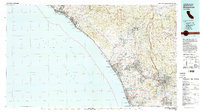
1982 Map of Oceanside
USGS Topo · Published 1983About this map
The vast Camp Pendleton Marine Corps Base dominates the coastline and interior of this 1982 survey, separating the growing coastal communities of North County San Diego from Orange County. The map captures a mix of military training grounds, coastal recreation at Doheny State Beach, and the inland agricultural and residential development around Vista and Fallbrook. Major infrastructure such as the San Onofre Nuclear Generating Station and the San Diego Freeway corridor are clearly visible, tracing the edge of the Gulf of Santa Catalina.
Find a feature on this map
77 named features on this map. Tap any name to fly to it.
Don’t see what you’re looking for? This feature index may not catch every label — zoom into the map to look around manually.
Map Details
Editions of this 1982 Oceanside Map
2 editions found
Other maps of this area

1893 · El Cajon
USGS Topo · 1:62,500

1893 · Oceanside
USGS Topo · 1:62,500

1893 · Escondido
USGS Topo · 1:62,500

1896 · Santa Ana
USGS Topo · 1:62,500

1896 · Las Bolsas
USGS Topo · 1:62,500

1898 · Oceanside
USGS Topo · 1:62,500

1901 · Southern California Sheet No. 1
USGS Topo · 1:250,000

1901 · Elcajon
USGS Topo · 1:62,500

1901 · Santa Ana
USGS Topo · 1:62,500

1901 · San Jacinto
USGS Topo · 1:125,000