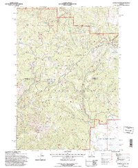
1992 Map of Ochoco Butte
USGS Topo · Published 1997About this map
The high timber and mountain ridges of the Ochoco National Forest define this central Oregon landscape, where the boundary between Wheeler and Crook counties cuts through the rugged interior. Activity centers on the extractive and recreational uses of the land, from the Ochoco Mine and Round Mtn Mine in the southwest to the developed camps near Walton Lake. The terrain is characterized by prominent peaks like Ochoco Butte and Slide Mountain, interspersed with secluded meadows and flats such as Carroll Glade and Corral Flat. Numerous water sources, including Lost Lake Spring and Big Spread Spring, support the local ecosystem and cattle operations, evidenced by the presence of a Gravel Pit and scattered stock ponds. The southeastern portion of the map opens into the wide expanse of Big Summit Prairie, providing a sharp contrast to the dense forest and complex drainage systems of Crystal Creek and Scissors Creek.
Find a feature on this map
62 named features on this map. Tap any name to fly to it.
Don’t see what you’re looking for? This feature index may not catch every label — zoom into the map to look around manually.
Map Details
Editions of this 1992 Ochoco Butte Map
This is the sole edition of this map. No revisions or reprints were ever made.
Other maps of this area

1926 · Mitchell
USGS Topo · 1:125,000

1951 · Lookout Mtn
USGS Topo · 1:62,500

1955 · Bend
USGS Topo · 1:250,000

1957 · Bend
USGS Topo · 1:250,000

1958 · Bend
USGS Topo · 1:250,000

1965 · Williams Prairie
USGS Topo · 1:24,000

1966 · Mt. Pisgah
USGS Topo · 1:24,000

1966 · Mitchell
USGS Topo · 1:62,500

1968 · Lawson Mtn
USGS Topo · 1:24,000

1968 · Stephenson Mtn
USGS Topo · 1:24,000