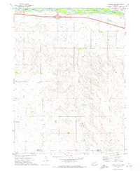
1971 Map of Ogallala SE
USGS Topo · Published 1973About this map
The South Platte River defines the northern edge of this Nebraska landscape, where the Union Pacific railroad and Interstate 80 parallel the waterway’s course. This corridor represents the modern evolution of a classic western transit route, with the survey capturing the rural character of the high plains in the early 1970s. Further south, the terrain transitions into a series of drainages, most notably Roscoe Draw, which cuts through the upland topography. Human presence is concentrated around essential community landmarks like St Johns Ch and School No 7, while the presence of the Cornelius Landing Strip indicates the importance of private aviation in this agricultural region. The boundary between Keith Co and Perkins Co runs along the southern portion of the map, marking a quiet divide in the open country where gravel extraction and a subsurface Pipeline reflect the area’s utility and infrastructure.
Find a feature on this map
11 named features on this map. Tap any name to fly to it.
Don’t see what you’re looking for? This feature index may not catch every label — zoom into the map to look around manually.
Map Details
Editions of this 1971 Ogallala SE Map
This is the sole edition of this map. No revisions or reprints were ever made.
Other maps of this area

1897 · Ogallala
USGS Topo · 1:125,000

1898 · Paxton
USGS Topo · 1:125,000

1900 · Ogallala
USGS Topo · 1:125,000

1901 · Paxton
USGS Topo · 1:125,000

1954 · McCook
USGS Topo · 1:250,000

1954 · North Platte
USGS Topo · 1:250,000

1956 · North Platte
USGS Topo · 1:250,000

1957 · North Platte
USGS Topo · 1:250,000

1957 · McCook
USGS Topo · 1:250,000

1958 · McCook
USGS Topo · 1:250,000