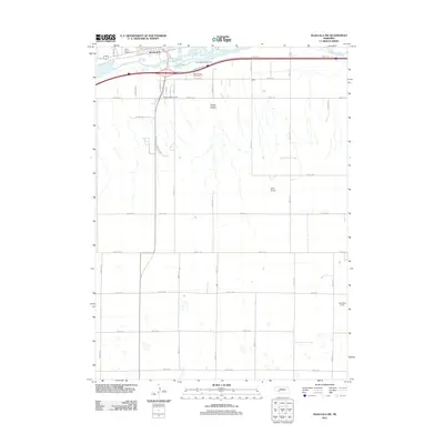
2011 Map of Ogallala SW
USGS Topo · Published 2011About this map
The South Platte River cuts across the northern edge of this 2011 landscape, marking the southern expansion of Ogallala into the High Plains. This area reflects a transition from the urban fringes of the county seat into a strictly organized agricultural grid, where the Keith County Fairgrounds serves as a bridge between town and country. Transportation routes dominate the northern corridor, with the modern paths of Stagecoach Trl and Old Hwy 61 S following the historical logic of the Platte Valley.
Find a feature on this map
37 named features on this map. Tap any name to fly to it.
Don’t see what you’re looking for? This feature index may not catch every label — zoom into the map to look around manually.
Map Details
Editions of this 2011 Ogallala SW Map
This is the sole edition of this map. No revisions or reprints were ever made.
Other maps of this area

1897 · Ogallala
USGS Topo · 1:125,000

1900 · Ogallala
USGS Topo · 1:125,000

1954 · McCook
USGS Topo · 1:250,000

1954 · North Platte
USGS Topo · 1:250,000

1956 · North Platte
USGS Topo · 1:250,000

1957 · North Platte
USGS Topo · 1:250,000

1957 · McCook
USGS Topo · 1:250,000

1958 · McCook
USGS Topo · 1:250,000

1961 · Brandon NE
USGS Topo · 1:24,000
1961 · Brule SE
USGS Topo · 1:24,000