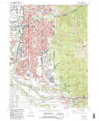
1992 Map of Ogden
USGS Topo · Published 1992About this map
The Weber River and Ogden River converge in this urban and mountain landscape, defining the industrial and residential heart of northern Utah during the late twentieth century. The map illustrates a city shaped by its logistics and defense role, prominently featuring the Defense Depot Ogden in the northwest and the northern edge of Hill Air Force Base along the southern border. Educational and religious institutions are dense here, ranging from the sprawling Weber State University campus at the base of the mountains to the Tabernacle and St Josephs High Sch in the city center.
Find a feature on this map
85 named features on this map. Tap any name to fly to it.
Don’t see what you’re looking for? This feature index may not catch every label — zoom into the map to look around manually.
Map Details
Editions of this 1992 Ogden Map
2 editions found
Other maps of this area

1954 · Ogden
USGS Topo · 1:250,000

1954 · Brigham City
USGS Topo · 1:250,000

1955 · Ogden
USGS Topo · 1:24,000

1955 · Plain City
USGS Topo · 1:24,000

1955 · Clearfield
USGS Topo · 1:24,000

1955 · Roy
USGS Topo · 1:24,000

1955 · Peterson
USGS Topo · 1:24,000

1955 · Huntsville
USGS Topo · 1:24,000

1955 · North Ogden
USGS Topo · 1:24,000

1955 · Kaysville
USGS Topo · 1:24,000