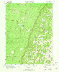
1971 Map of Ogletown
USGS Topo · Published 1973About this map
Babcock State Forest dominates the northern reaches of this landscape, where the high terrain of Pot Ridge is marked by multiple Strip Mine operations. This 1971 field-checked survey reveals a rugged transition between the forested highlands of the Ogle and Shade townships and the valley settlements to the southeast. The small community of Ogletown sits at a critical junction near Pine Lake, while the village of Ryot anchors the lower elevations along Dunning Creek. A complex network of drainage, including Clear Shade Creek and West Branch Georges Creek, cuts through the steep topography of Calvary Hollow. Local social and family history is anchored by rural landmarks like Calvary Ch, Dunning Creek Ch, and scattered Cem sites, providing a detailed view of the rural infrastructure in both Somerset and Bedford Counties.
Find a feature on this map
34 named features on this map. Tap any name to fly to it.
Don’t see what you’re looking for? This feature index may not catch every label — zoom into the map to look around manually.
Map Details
Editions of this 1971 Ogletown Map
4 editions found
Other maps of this area

1902 · Ebensburg
USGS Topo · 1:62,500

1904 · Ebensburg
USGS Topo · 1:62,500

1904 · Johnstown
USGS Topo · 1:62,500

1907 · Johnstown
USGS Topo · 1:62,500

1908 · Bedford
USGS Topo · 1:62,500

1910 · Bedford
USGS Topo · 1:62,500

1914 · Windber
USGS Topo · 1:62,500

1916 · Windber
USGS Topo · 1:62,500

1944 · Windber
USGS Topo · 1:62,500

1953 · Pittsburgh
USGS Topo · 1:250,000