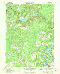
1967 Map of Ohiopyle
USGS Topo · Published 1970About this map
The Youghiogheny River carves a deep, winding path through this portion of the Laurel Highlands, shaping the development and transportation of the region. At the river's bend, the borough of Ohiopyle serves as a hub for both industry and recreation, surrounded by the expanse of Ohiopyle State Park. The map documents a critical intersection of historical transit, where the Baltimore and Ohio and the Western Maryland Railway follow the river's banks, while the historic National Road traverses the southern ridges near Elk Park.
Find a feature on this map
56 named features on this map. Tap any name to fly to it.
Don’t see what you’re looking for? This feature index may not catch every label — zoom into the map to look around manually.
Map Details
Editions of this 1967 Ohiopyle Map
3 editions found
Other maps of this area

1900 · Accident
USGS Topo · 1:62,500

1900 · Uniontown
USGS Topo · 1:62,500

1904 · Bruceton
USGS Topo · 1:62,500

1922 · Confluence
USGS Topo · 1:62,500

1926 · Bruceton
USGS Topo · 1:62,500

1931 · Uniontown
USGS Topo · 1:62,500

1931 · Confluence
USGS Topo · 1:62,500

1931 · Bruceton Mills
USGS Topo · 1:62,500

1933 · Confluence
USGS Topo · 1:62,500

1933 · Bruceton
USGS Topo · 1:62,500
Featured Places
- Ohiopyle, PA
- Addison Township, PA
- Lower Turkeyfoot Township, PA
- Wharton Township, PA
- Stewart Township, PA