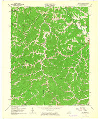
1962 Map of Oil Springs
USGS Topo · Published 1964About this map
Oil Springs serves as a focal point in this landscape where the boundaries of Johnson, Magoffin, and Morgan counties converge. The terrain is defined by a dense network of steep hollows and narrow ridges, such as Cotton Knob and Stuffley Knob, the latter featuring the Stuffley Knob Lookout Tower. This early 1960s survey captures a rural Kentucky community anchored by small country schools like Pigeon Sch and Low Gap Sch, and the presence of scattered Gas Wells indicates the region's long-standing reliance on natural resource extraction.
Find a feature on this map
68 named features on this map. Tap any name to fly to it.
Don’t see what you’re looking for? This feature index may not catch every label — zoom into the map to look around manually.
Map Details
Editions of this 1962 Oil Springs Map
3 editions found
Other maps of this area

1886 · Prestonsburg
USGS Topo · 1:125,000

1889 · Salyersville
USGS Topo · 1:125,000

1891 · Salyersville
USGS Topo · 1:125,000

1892 · Prestonsburg
USGS Topo · 1:125,000

1899 · Salyersville
USGS Topo · 1:125,000

1915 · Paintsville
USGS Topo · 1:48,000

1915 · Prestonsburg
USGS Topo · 1:62,500

1917 · Paintsville
USGS Topo · 1:62,500

1918 · Prestonsburg
USGS Topo · 1:62,500
1951 · Dingus
USGS Topo · 1:24,000