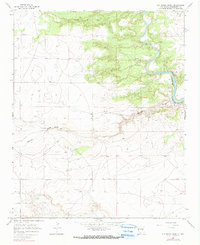
1966 Map of Ojo Negro Creek
USGS Topo · Published 1990About this map
The Pecos River carves a deep valley through this high desert terrain, serving as the primary geographical focus in this mid-1960s survey. The landscape is characterized by prominent erosion features like Cañon de Hughes and Borica Draw, which feed into the main waterway. Downstream, the river widens significantly as it enters the northern reaches of the Alamogordo Reservoir. Near the river bends, the Puerto de Luna Gaging Sta monitors the flow of these vital waters. The small settlement of Sena represents the sparse human habitation in this arid region, where ranching and water management define the local economy. Numerous Ruins are scattered across the mesas and along the banks of Ojo Negro Creek, indicating a long history of human presence and the persistence of land use in this demanding environment.
Find a feature on this map
10 named features on this map. Tap any name to fly to it.
Don’t see what you’re looking for? This feature index may not catch every label — zoom into the map to look around manually.
Map Details
Editions of this 1966 Ojo Negro Creek Map
2 editions found
Other maps of this area

1954 · Fort Sumner
USGS Topo · 1:250,000

1958 · Fort Sumner
USGS Topo · 1:250,000

1963 · Puerto Creek
USGS Topo · 1:24,000

1963 · Puerto De Luna
USGS Topo · 1:24,000

1964 · Fallon Ranch
USGS Topo · 1:24,000

1966 · Gibbons Ranch
USGS Topo · 1:24,000

1966 · Ojo Negro Creek
USGS Topo · 1:24,000

1966 · Alamogordo Dam
USGS Topo · 1:24,000

1966 · Borica SW
USGS Topo · 1:24,000

1966 · Cooper Ranch
USGS Topo · 1:24,000