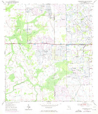
1953 Map of Okeechobee 1 NW
USGS Topo · Published 1971About this map
The county line between Okeechobee Co and St Lucie Co divides a landscape undergoing significant water management transformation during the mid-20th century. Numerous instances of Flowing Wells are scattered across the terrain, indicating the reliance on artesian water for local agriculture and livestock. The geography is increasingly defined by human engineering, with extensive Levees and a prominent Spoil Bank system established to control drainage in this low-lying region.
Find a feature on this map
9 named features on this map. Tap any name to fly to it.
Don’t see what you’re looking for? This feature index may not catch every label — zoom into the map to look around manually.
Map Details
Editions of this 1953 Okeechobee 1 NW Map
3 editions found
Other maps of this area

1953 · Okeechobee 1 SE
USGS Topo · 1:24,000

1953 · Fort Drum
USGS Topo · 1:24,000

1953 · Fellsmere 4 SE
USGS Topo · 1:24,000

1953 · Fellsmere 4 SW
USGS Topo · 1:24,000

1953 · Okeechobee 1 SW
USGS Topo · 1:24,000

1953 · Taylor Creek SE
USGS Topo · 1:24,000

1953 · Taylor Creek NE
USGS Topo · 1:24,000

1953 · Okeechobee 1 NE
USGS Topo · 1:24,000

1953 · Okeechobee 1 NW
USGS Topo · 1:24,000

1956 · Fort Pierce
USGS Topo · 1:250,000