2012 Map of Okeechobee SW
USGS Topo · Published 2012About this map
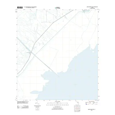
The northwest shoreline of Lake Okeechobee dominates this landscape, showing the highly engineered water management systems of south-central Florida in the early 21st century. The Indian Prairie Canal, also labeled as Indian Pr, cuts a straight path toward the lake, intersecting with the diagonal line of State Road 78. At this junction, the Indian Prairie Canal Bridge serves as a key crossing point in an area otherwise characterized by vast marshlands and open water. The map illustrates the geometric precision of the region's drainage and transport infrastructure, where human-made channels define the transition between the agricultural lands of Okeechobee County and the massive lake basin.
Find a feature on this map
3 named features on this map. Tap any name to fly to it.
Don’t see what you’re looking for? This feature index may not catch every label — zoom into the map to look around manually.
Map Details
Editions of this 2012 Okeechobee SW Map
This is the sole edition of this map. No revisions or reprints were ever made.
Other maps of this area

1952 · Okeechobee NW
USGS Topo · 1:24,000

1952 · Okeechobee
USGS Topo · 1:24,000

1953 · Brighton
USGS Topo · 1:24,000

1953 · Brighton SE
USGS Topo · 1:24,000

1953 · Okeechobee SW
USGS Topo · 1:24,000

1956 · West Palm Beach
USGS Topo · 1:250,000

1956 · Fort Pierce
USGS Topo · 1:250,000

1957 · West Palm Beach
USGS Topo · 1:250,000

1958 · Fort Pierce
USGS Topo · 1:250,000

1958 · West Palm Beach
USGS Topo · 1:250,000