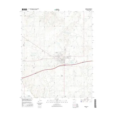
2016 Map of Okemah
USGS Topo · Published 2016About this map
The North Canadian River flows through the southern portion of this region, providing a natural boundary near the community of Bearden. The landscape is defined by the city of Okemah, where the street grid includes a thoroughfare named Woody Guthrie Blvd, honoring the folk singer's birthplace. The town's aviation history is visible at the Okemah Flying Field and nearby Airport Lake, while the surrounding rural area is dotted with numerous small family and community burial grounds including the Wind Family Cem, Foster Cem, and Harjo Cem. To the north and west, the terrain is shaped by several tributaries such as Buckeye Cr and Yhola Cr, along with numerous engineered water bodies like Oknoname 107035 Reservoir. Smaller settlements like Greenleaf sit along the section roads, illustrating the persistent rural network of Okfuskee County.
Find a feature on this map
61 named features on this map. Tap any name to fly to it.
Don’t see what you’re looking for? This feature index may not catch every label — zoom into the map to look around manually.
Map Details
Editions of this 2016 Okemah Map
This is the sole edition of this map. No revisions or reprints were ever made.
Other maps of this area
1900 · Wewoka
USGS Topo · 1:125,000
1901 · Nuyaka
USGS Topo · 1:125,000
1954 · Oklahoma City
USGS Topo · 1:250,000
1957 · Oklahoma City
USGS Topo · 1:250,000
1963 · Oklahoma City
USGS Topo · 1:250,000
1967 · Cromwell
USGS Topo · 1:24,000
1967 · Okemah SE
USGS Topo · 1:24,000
1967 · Weleetka
USGS Topo · 1:24,000
1967 · Okemah
USGS Topo · 1:24,000
1967 · Boley
USGS Topo · 1:24,000