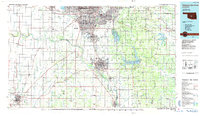
1985 Map of Oklahoma City South
USGS Topo · Published 1985About this map
The Canadian River serves as the dominant natural feature of this mid-1980s landscape, winding between the southern urban reaches of Oklahoma City and the expanding satellite communities of Norman and Moore. This planimetric study documents a region in transition, where established rail lines like the Atchison Topeka and Santa Fe and St Louis-San Francisco intersect with modern infrastructure like the H E Bailey Turnpike. Large institutional and military footprints are visible at Tinker Air Force Base and the Univ of Okla Westheimer Field, reflecting the area's significance in aviation and education.
Find a feature on this map
115 named features on this map. Tap any name to fly to it.
Don’t see what you’re looking for? This feature index may not catch every label — zoom into the map to look around manually.
Map Details
Editions of this 1985 Oklahoma City South Map
2 editions found
Other maps of this area

1892 · Moore
USGS Topo · 1:62,500

1892 · Edmond
USGS Topo · 1:62,500

1892 · Kingfisher
USGS Topo · 1:125,000

1893 · Norman
USGS Topo · 1:62,500

1893 · Fort Reno
USGS Topo · 1:62,500

1893 · Oklahoma City
USGS Topo · 1:62,500

1893 · Buggy Creek
USGS Topo · 1:62,500

1893 · Minco
USGS Topo · 1:62,500

1895 · Kingfisher
USGS Topo · 1:125,000

1896 · Seminole and Prague
USGS Topo · 1:125,000