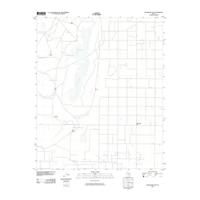
2010 Map of Oklahoma Flat
USGS Topo · Published 2010About this map
Yellow House Ranch and the small settlement at Oklahoma Flat anchor this corner of Hockley County, where the High Plains landscape is defined by its water management and ranching legacy. The terrain is characterized by a series of shallow basins and draws, notably Bull Draw and Goat Draw, which feed into ephemeral water bodies such as Illusion Lake and Yellow Lake. These natural features are supplemented by an extensive network of man-made tanks, including Rattlesnake Tank, Upper Goat Tank, and South Pasture Tank, illustrating the vital importance of water storage in this semi-arid environment.
Find a feature on this map
31 named features on this map. Tap any name to fly to it.
Don’t see what you’re looking for? This feature index may not catch every label — zoom into the map to look around manually.
Map Details
Editions of this 2010 Oklahoma Flat Map
This is the sole edition of this map. No revisions or reprints were ever made.
Other maps of this area

1954 · Brownfield
USGS Topo · 1:250,000

1958 · Brownfield
USGS Topo · 1:250,000

1962 · Brownfield
USGS Topo · 1:250,000

1964 · Oklahoma Flat
USGS Topo · 1:24,000

1964 · Littlefield
USGS Topo · 1:24,000
1964 · Bull Lake
USGS Topo · 1:24,000

1964 · Pep
USGS Topo · 1:24,000

1964 · Lums Chapel
USGS Topo · 1:24,000
1964 · Beck
USGS Topo · 1:24,000

1964 · Whitharral
USGS Topo · 1:24,000