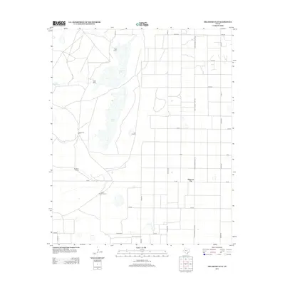
2012 Map of Oklahoma Flat
USGS Topo · Published 2012About this map
Yellow Lake and Illusion Lake dominate the central basin of this West Texas landscape, surrounded by the wide-ranging draws and windmills characteristic of the Llano Estacado. The settlement of Oklahoma Flat is situated amidst a rigid grid of rural roads such as Farm-to-Market Road 1490 and Cheyenne Rd. This area reflects a long history of ranching and resource extraction, anchored by the Yellow House Ranch and the southern Yellow House Oil Field. The reliance on groundwater is evident through scattered landmarks like Rye Straw Windmill, East Windmill, and South Pasture Windmill, which served the local cattle industry. The terrain is marked by seasonal drainage features including Bull Draw and Goat Draw, showing the subtle topography of the High Plains before modern irrigation further transformed the region.
Find a feature on this map
28 named features on this map. Tap any name to fly to it.
Don’t see what you’re looking for? This feature index may not catch every label — zoom into the map to look around manually.
Map Details
Editions of this 2012 Oklahoma Flat Map
This is the sole edition of this map. No revisions or reprints were ever made.
Other maps of this area

1954 · Brownfield
USGS Topo · 1:250,000

1958 · Brownfield
USGS Topo · 1:250,000

1962 · Brownfield
USGS Topo · 1:250,000

1964 · Oklahoma Flat
USGS Topo · 1:24,000

1964 · Littlefield
USGS Topo · 1:24,000
1964 · Bull Lake
USGS Topo · 1:24,000

1964 · Pep
USGS Topo · 1:24,000

1964 · Lums Chapel
USGS Topo · 1:24,000
1964 · Beck
USGS Topo · 1:24,000

1964 · Whitharral
USGS Topo · 1:24,000