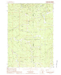
1984 Map of Old Baldy Mtn
USGS Topo · Published 1984About this map
Mining prospects and high-elevation springs dot this 1980s landscape along the border of Crook County, Wyoming, and Lawrence County, South Dakota. The settlement of Tinton serves as a focal point for historic extraction near Mineral Hill, surrounded by a dense network of operations including the Arctic No 2 Mine, Birdsnest Mine, and Peterson Mine. This area within the Black Hills National Forest is defined by a complex system of gulches and canyons, such as Rattlesnake Canyon and Riflepit Canyon, which historically necessitated numerous named water sources like Rattlesnake Spring No 1 and Guidinger Spring.
Find a feature on this map
70 named features on this map. Tap any name to fly to it.
Don’t see what you’re looking for? This feature index may not catch every label — zoom into the map to look around manually.
Map Details
Editions of this 1984 Old Baldy Mtn Map
This is the sole edition of this map. No revisions or reprints were ever made.
Other maps of this area

1894 · Deadwood
USGS Topo · 1:125,000

1898 · Sundance
USGS Topo · 1:125,000

1900 · Spearfish
USGS Topo · 1:62,500

1901 · Deadwood
USGS Topo · 1:125,000

1902 · Sundance
USGS Topo · 1:125,000

1915 · Spearfish
USGS Topo · 1:62,500

1916 · Deadwood
USGS Topo · 1:125,000

1953 · Rapid City
USGS Topo · 1:250,000

1954 · Gillette
USGS Topo · 1:250,000

1955 · Gillette
USGS Topo · 1:250,000