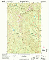
2001 Map of Old Baldy
USGS Topo · Published 2004About this map
Okanogan National Forest dominates this high-elevation landscape at the turn of the millennium, characterized by a complex network of ridges and drainage basins. The area is anchored by prominent peaks including Old Baldy, Starvation Mountain, and Mount McCay, which serve as the headwaters for numerous water systems such as Middle Fork Boulder Creek and West Fork Salmon Creek. A specialized infrastructure for forest management is evident through the inclusion of a Heliport and a Quarry, while the boundary between the Methow Tonasket Ranger District and the Tonasket Methow Ranger District bisects the terrain.
Find a feature on this map
42 named features on this map. Tap any name to fly to it.
Don’t see what you’re looking for? This feature index may not catch every label — zoom into the map to look around manually.
Map Details
Editions of this 2001 Old Baldy Map
This is the sole edition of this map. No revisions or reprints were ever made.
Other maps of this area

1899 · Methow
USGS Topo · 1:125,000

1901 · Methow
USGS Topo · 1:125,000

1905 · Okanogan
USGS Topo · 1:125,000

1906 · Chopaka
USGS Topo · 1:125,000

1954 · Okanogan
USGS Topo · 1:250,000

1955 · Concrete
USGS Topo · 1:250,000

1956 · Loup Loup
USGS Topo · 1:62,500

1956 · Tiffany Mountain
USGS Topo · 1:62,500

1958 · Concrete
USGS Topo · 1:250,000

1958 · Okanogan
USGS Topo · 1:250,000