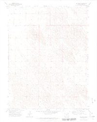
1971 Map of Old Baldy
USGS Topo · Published 1974About this map
Old Baldy rises above the rolling high plains of eastern Colorado in this 1971 study by the Department of the Interior. The landscape is characterized by its sparse settlement and the vital importance of groundwater, evidenced by several scattered wells and windmills throughout the quadrangle. Aside from the namesake summit, the terrain includes localized landmarks like Brophy and various structures marked Wm. This survey, produced from photogrammetric methods based on 1970 aerial photography, illustrates a moment in time when the remote corners of Yuma County remained largely dedicated to open range and isolated ranching operations. The detailed contour intervals reveal the subtle variations in elevation across this part of the Western Great Plains.
Find a feature on this map
4 named features on this map. Tap any name to fly to it.
Don’t see what you’re looking for? This feature index may not catch every label — zoom into the map to look around manually.
Map Details
Editions of this 1971 Old Baldy Map
3 editions found
Other maps of this area

1954 · Sterling
USGS Topo · 1:250,000

1958 · Sterling
USGS Topo · 1:250,000

1971 · Fiddler Peak
USGS Topo · 1:24,000

1971 · Wauneta NE
USGS Topo · 1:24,000

1971 · Clarkville NE
USGS Topo · 1:24,000

1971 · Yuma NE
USGS Topo · 1:24,000

1971 · Wauneta
USGS Topo · 1:24,000

1971 · Eckley NE
USGS Topo · 1:24,000

1971 · Clarkville SE
USGS Topo · 1:24,000

1971 · Old Baldy
USGS Topo · 1:24,000