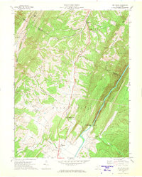
1970 Map of Old Fields
USGS Topo · Published 1973About this map
Purgitsville and the Old Fields settlement anchor this landscape in the Potomac Highlands, where the topography is defined by the narrow valley of the Potomac River (South Branch). The transportation network of the 1970s follows these natural corridors, with the Baltimore and Ohio railroad and winding paths like Elmlick Road connecting local communities. The map provides a detailed view of rural infrastructure, including several small churches such as Old Pine Ch, Otterbein Ch, and Bethel Ch, alongside the Mill Creek Sch. Strategic mountain passes like Reynolds Gap and Falling Springs Gap reveal how the geology dictated movement between Hardy Co and Hampshire Co. Local landmarks like Taylor Knob and Thrasher Knob rise above the drainage basins of Mill Creek and Patterson Creek, illustrating the complex drainage patterns of this Appalachian region.
Find a feature on this map
42 named features on this map. Tap any name to fly to it.
Don’t see what you’re looking for? This feature index may not catch every label — zoom into the map to look around manually.
Map Details
Editions of this 1970 Old Fields Map
This is the sole edition of this map. No revisions or reprints were ever made.
Other maps of this area

1891 · Romney
USGS Topo · 1:125,000

1895 · Piedmont
USGS Topo · 1:125,000

1919 · Elk Garden
USGS Topo · 1:48,000

1920 · Elk Garden
USGS Topo · 1:48,000

1920 · Moorefield
USGS Topo · 1:62,500

1920 · Keyser
USGS Topo · 1:62,500

1921 · Keyser
USGS Topo · 1:48,000

1921 · Greenland Gap
USGS Topo · 1:62,500

1921 · Moorefield
USGS Topo · 1:48,000

1922 · Elk Garden
USGS Topo · 1:62,500