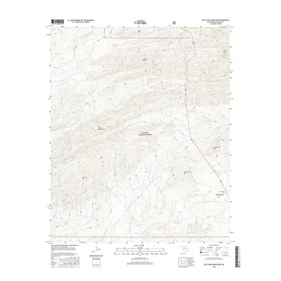
2016 Map of Old Glory Mountain
USGS Topo · Published 2016About this map
Ouachita National Forest dominates this landscape in McCurtain County, defined by the drainage basins of the Lukfata and Carter creek systems. In the southeast corner, the community of Hochatown sits as a primary point of reference, accompanied by the nearby Hochatown Cem. The terrain is characterized by significant elevations including Old Glory Mtn and the twin summits of W High Peak and E High Peak. Water sources are numerous and include family-named landmarks such as Brigham Young Springs and Government Spring. The network of watercourses, including W Fork Lukfata Cr and Middle Fork Lukfata Cr, suggests a rugged topography managed for timber and conservation. High ridges like the Cedar Mountains and Carter Mtn further delineate the remote character of this forest interior in the 2010s.
Find a feature on this map
33 named features on this map. Tap any name to fly to it.
Don’t see what you’re looking for? This feature index may not catch every label — zoom into the map to look around manually.
Map Details
Editions of this 2016 Old Glory Mountain Map
This is the sole edition of this map. No revisions or reprints were ever made.
Other maps of this area

1902 · Lukfata
USGS Topo · 1:125,000

1950 · Mcalester
USGS Topo · 1:250,000

1959 · Golden
USGS Topo · 1:62,500

1959 · Broken Bow
USGS Topo · 1:62,500

1960 · Bethel
USGS Topo · 1:62,500

1960 · Smithville
USGS Topo · 1:62,500

1962 · McAlester
USGS Topo · 1:250,000

1965 · McAlester
USGS Topo · 1:250,000
1976 · Broken Bow SW
USGS Topo · 1:24,000
1981 · Hee Creek
USGS Topo · 1:24,000