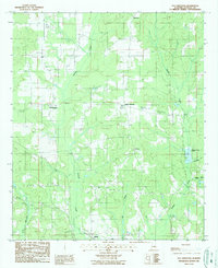
1987 Map of Old Kingston
USGS Topo · Published 1987About this map
Old Kingston and the surrounding Autauga County countryside are captured here in the late 1980s, revealing a landscape defined by its network of creeks and small crossroads. The area is dominated by the winding course of Autauga Creek as it flows south toward Booth, while the eastern portion of the quadrangle is shaped by Bridge Creek and Bridge Creek Lake.
Find a feature on this map
18 named features on this map. Tap any name to fly to it.
Don’t see what you’re looking for? This feature index may not catch every label — zoom into the map to look around manually.
Map Details
Editions of this 1987 Old Kingston Map
This is the sole edition of this map. No revisions or reprints were ever made.
Other maps of this area

1891 · Clanton
USGS Topo · 1:125,000

1901 · Wetumpka
USGS Topo · 1:125,000

1903 · Wetumpka
USGS Topo · 1:125,000

1927 · Montgomery
USGS Topo · 1:48,000

1930 · Montgomery
USGS Topo · 1:62,500

1953 · Montgomery
USGS Topo · 1:250,000

1956 · Montgomery
USGS Topo · 1:250,000

1957 · Montgomery
USGS Topo · 1:250,000

1957 · Autaugaville
USGS Topo · 1:62,500

1958 · Montgomery
USGS Topo · 1:62,500