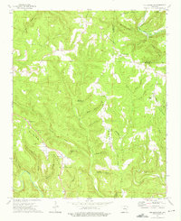
1973 Map of Old Lexington
USGS Topo · Published 1975About this map
Old Lexington and Old Botkinburg serve as the primary landmarks in this upland region of Arkansas, situated along the border of Van Buren and Stone counties. The landscape is defined by its dramatic relief, where the Middle Fork Little Red River and Linn Creek carve through high elevations like Half Moon Mountain and Clinton Mountain. The settlement pattern reflects a reliance on these elevated ridges and hollows, with rural life centered around community focal points such as Shady Grove Ch, Corinth Ch, and the Holly Mountain Cem. A notable geological feature, the Natural Bridge, sits near Johnnies Hollow, illustrating the unique sandstone topography of the area. Economic and logistical activity is marked by a Quarry near Mountain View Ch and a remote Landing Strip nestled in the northern hills, showing how the local population adapted to the complex terrain during the early 1970s.
Find a feature on this map
49 named features on this map. Tap any name to fly to it.
Don’t see what you’re looking for? This feature index may not catch every label — zoom into the map to look around manually.
Map Details
Editions of this 1973 Old Lexington Map
2 editions found
Other maps of this area

1892 · Marshall
USGS Topo · 1:125,000

1892 · Mountain View
USGS Topo · 1:125,000

1894 · Mountain View
USGS Topo · 1:125,000

1894 · Marshall
USGS Topo · 1:125,000

1901 · Marshall
USGS Topo · 1:125,000

1956 · Russellville
USGS Topo · 1:250,000

1963 · Leslie
USGS Topo · 1:24,000

1964 · Russellville
USGS Topo · 1:250,000
1965 · Botkinburg
USGS Topo · 1:24,000
1965 · Scotland
USGS Topo · 1:24,000