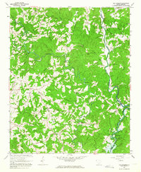
1961 Map of Old Pickens
USGS Topo · Published 1964About this map
Old Pickens and the settlement of Rothwell anchor this corner of the Oconee and Pickens county line in the early 1960s. The landscape is defined by the winding paths of the Little River and Keowee River, which meet near the southern edge of the sheet. At the time of this field check, the rising waters of the Hartwell Reservoir are visible as a growing influence on the local geography, inundating several low-lying branches and creek bottoms.
Find a feature on this map
62 named features on this map. Tap any name to fly to it.
Don’t see what you’re looking for? This feature index may not catch every label — zoom into the map to look around manually.
Map Details
Editions of this 1961 Old Pickens Map
3 editions found
Other maps of this area

1886 · Walhalla
USGS Topo · 1:125,000

1888 · Pickens
USGS Topo · 1:125,000

1892 · Walhalla
USGS Topo · 1:125,000

1894 · Pickens
USGS Topo · 1:125,000

1896 · Walhalla
USGS Topo · 1:125,000

1951 · Clemson
USGS Topo · 1:24,000

1954 · Greenville
USGS Topo · 1:250,000

1958 · Greenville
USGS Topo · 1:250,000

1958 · Seneca
USGS Topo · 1:24,000

1959 · Salem
USGS Topo · 1:24,000