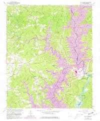
1961 Map of Old Pickens
USGS Topo · Published 1981About this map
The historic settlement of Old Pickens and its surrounding river valleys define this 1961 survey, which was later updated to show the rising waters of Lake Keowee. This map documents a landscape in transition as the Keowee River and Little River are transformed by major hydroelectric and reservoir projects. Genealogists will find a wealth of country churches and family-linked burial grounds, including Isaqueena Cemetery, St. Peters Church, and Old Pickens Cemetery near the river's Big Bend. The topography also highlights the Keowee High School and industrial footprints such as a power plant and various substations. Local landmarks like Wolfs Stake and the lookout tower near Stamp Creek Church provide specific navigational points in the hills above the Hartwell Reservoir.
Find a feature on this map
74 named features on this map. Tap any name to fly to it.
Don’t see what you’re looking for? This feature index may not catch every label — zoom into the map to look around manually.
Map Details
Editions of this 1961 Old Pickens Map
3 editions found
Other maps of this area

1886 · Walhalla
USGS Topo · 1:125,000

1888 · Pickens
USGS Topo · 1:125,000

1892 · Walhalla
USGS Topo · 1:125,000

1894 · Pickens
USGS Topo · 1:125,000

1896 · Walhalla
USGS Topo · 1:125,000

1951 · Clemson
USGS Topo · 1:24,000

1954 · Greenville
USGS Topo · 1:250,000

1958 · Greenville
USGS Topo · 1:250,000

1958 · Seneca
USGS Topo · 1:24,000

1959 · Salem
USGS Topo · 1:24,000