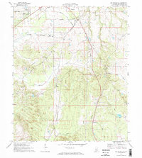
1970 Map of Old Spring Hill
USGS Topo · Published 1973About this map
The settlement of Old Spring Hill and the southeastern outskirts of Demopolis define this rural landscape in Marengo County during the early 1970s. The map reveals a community structured by faith and tradition, with numerous rural congregations including Mt Canaan Ch, Nazareth of Galilee Ch, and St Lukes Ch dotting the terrain. The infrastructure of the era is evident through the path of the St Louis-San Francisco railroad and a network of pipelines and pumping stations that cut across the local drainage basins of Falling Creek and Double Creek. Natural water features like Lake Miriam and the winding course of French Creek suggest a landscape primarily shaped by agriculture and local hydrology. For genealogists and local historians, the inclusion of sites like the Memorial Garden (Cem) and smaller unnamed cemeteries provides essential points of reference for family research in this part of the Alabama Black Belt.
Find a feature on this map
30 named features on this map. Tap any name to fly to it.
Don’t see what you’re looking for? This feature index may not catch every label — zoom into the map to look around manually.
Map Details
Editions of this 1970 Old Spring Hill Map
2 editions found

Other maps of this area

1946 · Demopolis
USGS Topo · 1:24,000

1947 · Demopolis
USGS Topo · 1:24,000

1948 · Mc Dowell
USGS Topo · 1:24,000

1949 · Mc Dowell
USGS Topo · 1:24,000

1953 · Montgomery
USGS Topo · 1:250,000

1956 · Montgomery
USGS Topo · 1:250,000

1957 · Montgomery
USGS Topo · 1:250,000

1968 · Thomaston West
USGS Topo · 1:24,000

1968 · Gallion
USGS Topo · 1:24,000

1970 · Myrtlewood North
USGS Topo · 1:24,000