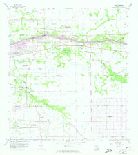
1958 Map of Olga
USGS Topo · Published 1974About this map
The Caloosahatchee River serves as the central artery for this Lee County region, with numerous tributaries like Trout Creek, Otter Creek, and Telegraph Creek feeding into the main channel. Settlement patterns in the mid-20th century show a mix of established riverside communities like Olga and emerging developments including Ft Myers Shores and Telegraph Estates. Further inland, the vast planned grid of Lehigh Acres begins to take shape with named waterways like George Canal and West Easy Canal.
Find a feature on this map
28 named features on this map. Tap any name to fly to it.
Don’t see what you’re looking for? This feature index may not catch every label — zoom into the map to look around manually.
Map Details
Editions of this 1958 Olga Map
4 editions found
Other maps of this area

1956 · Telegraph Swamp
USGS Topo · 1:24,000

1956 · West Palm Beach
USGS Topo · 1:250,000

1957 · West Palm Beach
USGS Topo · 1:250,000

1957 · Tuckers Corner
USGS Topo · 1:24,000

1957 · Telegraph Swamp SE
USGS Topo · 1:24,000

1958 · West Palm Beach
USGS Topo · 1:250,000

1958 · Olga
USGS Topo · 1:24,000

1958 · Alva SW
USGS Topo · 1:24,000

1958 · Fort Myers
USGS Topo · 1:24,000

1958 · Alva
USGS Topo · 1:24,000