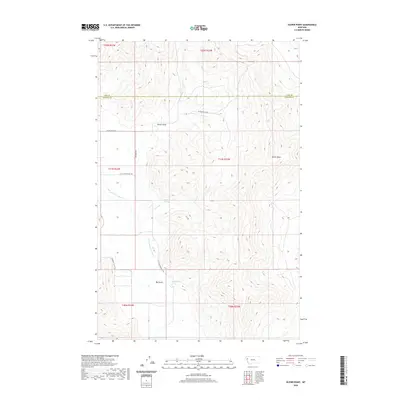
2020 Map of Oliver Point
USGS Topo · Published 2020About this map
The Little Bitterroot River winds through the southwestern portion of this landscape, carving a path between the elevated terrain of Oliver Point and the lower elevations of the river valley. This 2020 survey highlights the boundary between Lake Co and Sanders Co, illustrating how the jurisdictional line crosses over various gulches and ridges. The map is defined by its water sources, including Sullivan Spring and Magpie Spring, which provide essential moisture in this environment.
Find a feature on this map
18 named features on this map. Tap any name to fly to it.
Don’t see what you’re looking for? This feature index may not catch every label — zoom into the map to look around manually.
Map Details
Editions of this 2020 Oliver Point Map
This is the sole edition of this map. No revisions or reprints were ever made.
Other maps of this area

1920 · Flathead Lake
USGS Topo · 1:125,000

1956 · Wallace
USGS Topo · 1:250,000

1959 · Perma
USGS Topo · 1:62,500

1960 · Wallace
USGS Topo · 1:250,000

1964 · Buffalo Bridge
USGS Topo · 1:24,000

1964 · Melton Ranch
USGS Topo · 1:24,000

1964 · Markle Pass
USGS Topo · 1:24,000
1964 · Hot Springs NE
USGS Topo · 1:24,000

1965 · Sloan
USGS Topo · 1:24,000

1965 · Oliver Point
USGS Topo · 1:24,000