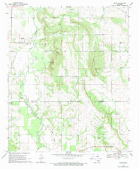
1969 Map of Olney
USGS Topo · Published 1971About this map
Olney sits at the western edge of a landscape defined by the winding course of Clear Boggy Creek and its tributaries during the late 1960s. The terrain transitions from the open stretches of Ash Flat to the more prominent elevations of Davis Mountain and Flagpole Mountain. A legacy of earlier transportation is visible in the Old Railroad Grade that cuts through the northern sections, while the natural hydrology is marked by features like Old Grassy Lake and the deep incision of Clear Creek Canyon. Genealogists and local historians will find significant value in the distribution of family and community burial grounds, including Davis Cem, Sealy Cem, and Standing Rock Cem. The map also documents the transition across the Coal County and Atoka County line, capturing the rural character of this Oklahoma region before modern development altered its traditional land use patterns.
Find a feature on this map
32 named features on this map. Tap any name to fly to it.
Don’t see what you’re looking for? This feature index may not catch every label — zoom into the map to look around manually.
Map Details
Editions of this 1969 Olney Map
This is the sole edition of this map. No revisions or reprints were ever made.
Other maps of this area

1896 · Coalgate
USGS Topo · 1:125,000

1899 · Coalgate
USGS Topo · 1:125,000

1899 · Atoka
USGS Topo · 1:125,000

1900 · Atoka
USGS Topo · 1:125,000

1900 · Coalgate
USGS Topo · 1:125,000

1957 · Coalgate
USGS Topo · 1:24,000

1957 · Lehigh
USGS Topo · 1:24,000

1957 · Centrahoma
USGS Topo · 1:24,000

1957 · Ardmore
USGS Topo · 1:250,000

1963 · Ardmore
USGS Topo · 1:250,000