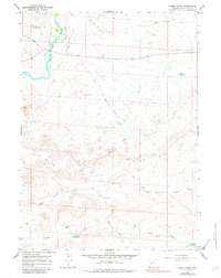
1964 Map of Olsen Ranch
USGS Topo · Published 1982About this map
The New Fork River winds through the northern reaches of this Sublette County landscape, flanked by the Bertram Ditch and Butler Ditch irrigation networks. This mid-1960s terrain is defined by its ranching infrastructure and historic passage, most notably the path of the Emigrant Trail cutting across the northern sections. Central to the local operations is the Olsen Ranch, positioned near the junction of drainage systems and the long Blue Rim Drift Fence that follows the edge of the Blue Rim plateau. The map records a water-scarce environment managed through man-made features like the Granite Reservoir and Wild Horse Reservoir, alongside natural features such as Ross Ridge and the broad North Alkali Draw. The presence of the Burma Road underscores the development of backcountry access across the high desert flats of The Mesa.
Find a feature on this map
16 named features on this map. Tap any name to fly to it.
Don’t see what you’re looking for? This feature index may not catch every label — zoom into the map to look around manually.
Map Details
Editions of this 1964 Olsen Ranch Map
2 editions found
Other maps of this area

1955 · Lander
USGS Topo · 1:250,000

1958 · Lander
USGS Topo · 1:250,000

1961 · Lander
USGS Topo · 1:250,000

1964 · Two Buttes Reservoir
USGS Topo · 1:24,000

1964 · Ross Butte
USGS Topo · 1:24,000
1964 · Olsen Ranch
USGS Topo · 1:24,000

1964 · Mesa Spring
USGS Topo · 1:24,000

1964 · Boulder
USGS Topo · 1:24,000
1969 · Sugar Loaf NW
USGS Topo · 1:24,000
1969 · Sugar Loaf NE
USGS Topo · 1:24,000