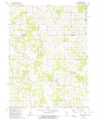
1980 Map of Omaha
USGS Topo · Published 1980About this map
Omaha and the surrounding borderlands of Putnam County and Appanoose County reveal a landscape defined by both agrarian life and industrial extraction. The topography is deeply carved by drainage systems like Shoal Cr and Turkey Creek, which create the winding ridges where most of the early infrastructure is located. The prominence of Strip Mines in the western half of the map indicates a significant mid-to-late 20th-century coal operations phase that altered the natural contours near Esper. Numerous family and community burying grounds, including Union Cem and Shipley Cem, are scattered across the rural townships of Liberty and Caldwell, offering vital spatial data for genealogical research. Small cultural centers like Mt Hermon Ch and the settlement of Chariton provide focal points for the dispersed farming community along the Iowa Missouri state line.
Find a feature on this map
28 named features on this map. Tap any name to fly to it.
Don’t see what you’re looking for? This feature index may not catch every label — zoom into the map to look around manually.
Map Details
Editions of this 1980 Omaha Map
This is the sole edition of this map. No revisions or reprints were ever made.
Other maps of this area

1911 · Queen City
USGS Topo · 1:62,500

1912 · Green City
USGS Topo · 1:62,500

1913 · Queen City
USGS Topo · 1:62,500

1914 · Green City
USGS Topo · 1:62,500

1939 · Centerville
USGS Topo · 1:62,500

1941 · Centerville
USGS Topo · 1:62,500

1954 · Centerville
USGS Topo · 1:250,000

1957 · Centerville
USGS Topo · 1:250,000

1958 · Centerville
USGS Topo · 1:250,000
1974 · Green City NW
USGS Topo · 1:24,000