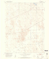
1951 Map of Omar
USGS Topo · Published 1959About this map
Omar and the surrounding high plains of northeastern Colorado appear here as they were documented by surveys in 1951. The landscape is defined by its intermittent water sources and the infrastructure required to sustain life in an arid environment, notably the numerous Well and Windmill sites scattered across the township lines. The border between Weld Co and Morgan Co bisects the eastern portion of the sheet, where the Empire Reservoir and West Nile Reservoir (Abandoned) provided critical irrigation storage for the region's agricultural efforts. Transportation and commerce were anchored by the Chicago Burlington and railroad line, which runs diagonally through the center of the quadrangle. Drainage patterns are dominated by the winding paths of Kiowa Creek, Rock Creek, and Jack Rabbit Creek, which carve subtle relief into the terrain alongside local landmarks such as Quincy and the prominent Crest.
Find a feature on this map
12 named features on this map. Tap any name to fly to it.
Don’t see what you’re looking for? This feature index may not catch every label — zoom into the map to look around manually.
Map Details
Editions of this 1951 Omar Map
5 editions found
Other maps of this area

1950 · Wiggins
USGS Topo · 1:24,000

1950 · South Roggen
USGS Topo · 1:24,000

1950 · Wiggins SW
USGS Topo · 1:24,000

1950 · Masters
USGS Topo · 1:24,000

1950 · Hoyt
USGS Topo · 1:24,000

1951 · Hoyt
USGS Topo · 1:24,000

1951 · Masters
USGS Topo · 1:24,000

1951 · Orchard
USGS Topo · 1:24,000

1951 · Roggen
USGS Topo · 1:24,000

1951 · Omar
USGS Topo · 1:24,000