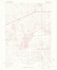
1951 Map of Omar
USGS Topo · Published 1972About this map
Omar sits as a lonely rail point in the high plains of eastern Colorado, established where the Burlington Northern line cuts across the arid landscape of the Weld and Morgan county border. This survey, based on early 1950s field work with 1970s revisions, illustrates a water-dependent economy defined by ephemeral drainages and essential infrastructure. The northern edge is dominated by the Empire Reservoir, while the southern reaches are marked by the winding paths of Kiowa Creek, Rock Creek, and Jack Rabbit Creek.
Find a feature on this map
11 named features on this map. Tap any name to fly to it.
Don’t see what you’re looking for? This feature index may not catch every label — zoom into the map to look around manually.
Map Details
Editions of this 1951 Omar Map
5 editions found
Other maps of this area

1950 · Wiggins
USGS Topo · 1:24,000

1950 · South Roggen
USGS Topo · 1:24,000

1950 · Wiggins SW
USGS Topo · 1:24,000

1950 · Masters
USGS Topo · 1:24,000

1950 · Hoyt
USGS Topo · 1:24,000

1951 · Hoyt
USGS Topo · 1:24,000

1951 · Masters
USGS Topo · 1:24,000

1951 · Orchard
USGS Topo · 1:24,000

1951 · Roggen
USGS Topo · 1:24,000

1951 · Omar
USGS Topo · 1:24,000