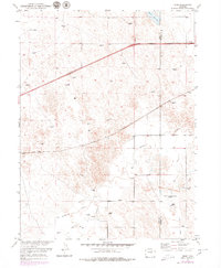
1951 Map of Omar
USGS Topo · Published 1979About this map
The Weld Co Morgan Co line bisects this plains landscape, where the small settlement of Omar sits along the Burlington Northern railroad. The map reflects a water-dependent agricultural economy in the Colorado High Plains, marked by numerous windmills used to tap groundwater for livestock and domestic use. The drainage system is defined by intermittent flows like Kiowa Creek and Jack Rabbit Creek, which cut through the sandy, contoured terrain towards larger catchments. The presence of the West Nile Reservoir (Abandoned) in the southeast suggests shifting water management priorities or environmental changes between the initial 1951 planetable surveys and the late-1970s revisions. To the north, the substantial Empire Reservoir dominates the corner of the quadrangle, serving as a primary landmark in an otherwise sparse region of ranching and rail infrastructure.
Find a feature on this map
11 named features on this map. Tap any name to fly to it.
Don’t see what you’re looking for? This feature index may not catch every label — zoom into the map to look around manually.
Map Details
Editions of this 1951 Omar Map
5 editions found
Other maps of this area

1950 · Wiggins
USGS Topo · 1:24,000

1950 · South Roggen
USGS Topo · 1:24,000

1950 · Wiggins SW
USGS Topo · 1:24,000

1950 · Masters
USGS Topo · 1:24,000

1950 · Hoyt
USGS Topo · 1:24,000

1951 · Hoyt
USGS Topo · 1:24,000

1951 · Masters
USGS Topo · 1:24,000

1951 · Orchard
USGS Topo · 1:24,000

1951 · Roggen
USGS Topo · 1:24,000

1951 · Omar
USGS Topo · 1:24,000