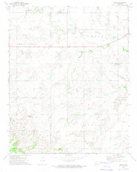
1972 Map of Omega
USGS Topo · Published 1974About this map
Kingfisher County's agricultural and energy-producing landscape is clearly defined in this early 1970s survey. The small settlement of Omega sits near the northern boundary, while the community of Altona anchors the southern half of the quadrangle. The terrain is characterized by the broad Cedar Valley and the prominent Cheyenne Butte, with the land drained by Kingfisher Creek and its tributaries, including Cedar Cr and Otter Creek.
Find a feature on this map
16 named features on this map. Tap any name to fly to it.
Don’t see what you’re looking for? This feature index may not catch every label — zoom into the map to look around manually.
Map Details
Editions of this 1972 Omega Map
This is the sole edition of this map. No revisions or reprints were ever made.
Other maps of this area

1893 · Fort Reno
USGS Topo · 1:62,500

1893 · Loyal
USGS Topo · 1:62,500

1941 · Fort Reno
USGS Topo · 1:62,500

1942 · Fort Reno
USGS Topo · 1:62,500

1942 · Geary
USGS Topo · 1:62,500

1949 · Fort Reno
USGS Topo · 1:62,500

1955 · Clinton
USGS Topo · 1:250,000

1957 · Clinton
USGS Topo · 1:250,000
1972 · Loyal SE
USGS Topo · 1:24,000

1972 · Watonga SE
USGS Topo · 1:24,000