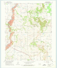
1963 Map of Oneta
USGS Topo · Published 1975About this map
Strip mines dominate the western hills of Wagoner County in the early 1960s, reflecting the industrial legacy of the Oklahoma coalfields. The Missouri-Kansas-Texas railroad cuts diagonally through the southern half of the landscape, providing a vital transport link for the settlement at Oneta. This era shows a community structured around rural education and faith, with numerous neighborhood institutions like Blue Springs Sch, Oneta Sch, and the Baptist Ch serving the local population. Deep family roots are evident in the scatter of burial grounds across the terrain, including Smith Cem, Springtown Cem, and Oak Grove Cem. The geography is defined by the drainage of Adams Creek and Coal Creek, while the prominent rise of Lone Star and the broad flats of Big Bottom mark the distinctive topography of the region.
Find a feature on this map
25 named features on this map. Tap any name to fly to it.
Don’t see what you’re looking for? This feature index may not catch every label — zoom into the map to look around manually.
Map Details
Editions of this 1963 Oneta Map
3 editions found
Other maps of this area

1896 · Okmulgee
USGS Topo · 1:125,000

1900 · Okmulgee
USGS Topo · 1:125,000

1901 · Claremore
USGS Topo · 1:125,000

1914 · Claremore
USGS Topo · 1:125,000

1916 · Claremore
USGS Topo · 1:125,000

1946 · Fort Smith
USGS Topo · 1:250,000

1954 · Tulsa
USGS Topo · 1:250,000

1955 · Mingo
USGS Topo · 1:24,000

1955 · Broken Arrow
USGS Topo · 1:24,000

1957 · Leonard
USGS Topo · 1:24,000