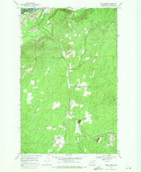
1969 Map of Onion Creek
USGS Topo · Published 1971About this map
Franklin D Roosevelt Lake and the Columbia River anchor the northwest corner of this Northeast Washington landscape, where the Coulee Dam Nat Recreation Area Bdy meets the peaks of the Selkirk Mountains. The topography is defined by significant elevations like Alice Mae Mountain, Bodie Mountain, and Staghorn Mtn, with the drainage of Onion Creek and its West Fork carving through the center of the sheet.
Find a feature on this map
23 named features on this map. Tap any name to fly to it.
Don’t see what you’re looking for? This feature index may not catch every label — zoom into the map to look around manually.
Map Details
Editions of this 1969 Onion Creek Map
3 editions found
Other maps of this area

1929 · Colville
USGS Topo · 1:125,000

1933 · Colville
USGS Topo · 1:125,000

1952 · Gillette Mtn
USGS Topo · 1:24,000

1952 · Spirit
USGS Topo · 1:24,000

1952 · Echo Valley
USGS Topo · 1:24,000

1952 · Boundary
USGS Topo · 1:24,000

1952 · Aladdin
USGS Topo · 1:24,000

1958 · Sandpoint
USGS Topo · 1:250,000

1963 · Sandpoint
USGS Topo · 1:250,000
1966 · Aladdin
USGS Topo · 1:24,000