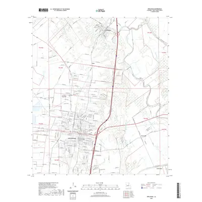
2020 Map of Opelousas
USGS Topo · Published 2020About this map
Opelousas serves as the focal point of this St. Landry Parish survey, displaying a dense urban grid centered on the Saint Landry Parish Courthouse. The surrounding Acadiana landscape is defined by its intricate bayou systems, where the winding courses of Bayou Tesson and Bayou Bellevue meet the city's edge. To the north, the historic river port of Washington sits near the confluence of Bayou Courtableau and Bayou Carron, maintaining a street plan that reflects its heritage at the head of navigation. Educational and transport infrastructure is well represented by the South Louisiana Community College T H Harris Campus and St Landry Parish Airport-Ahart Field. Smaller communities like Nuba and Boscoville occupy the rural spaces between these larger hubs, while numerous burial grounds, including Hebrew Rest Cem and Myrtle Grove Cem, provide vital touchpoints for local genealogical research.
Find a feature on this map
40 named features on this map. Tap any name to fly to it.
Don’t see what you’re looking for? This feature index may not catch every label — zoom into the map to look around manually.
Map Details
Editions of this 2020 Opelousas Map
This is the sole edition of this map. No revisions or reprints were ever made.
Other maps of this area

1939 · Opelousas
USGS Topo · 1:62,500

1940 · Arnaudville
USGS Topo · 1:62,500

1952 · Lake Charles
USGS Topo · 1:250,000

1954 · Lake Charles
USGS Topo · 1:250,000

1954 · Baton Rouge
USGS Topo · 1:250,000

1956 · Opelousas
USGS Topo · 1:62,500

1956 · Baton Rouge
USGS Topo · 1:250,000

1957 · Opelousas
USGS Topo · 1:62,500

1957 · Carencro
USGS Topo · 1:62,500

1959 · Palmetto
USGS Topo · 1:62,500