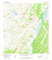
1965 Map of Ophir B-2
USGS Topo · Published 1966About this map
The Innoko River meanders through this Interior Alaska landscape, defining a remote region of the Yukon-Koyukuk during the mid-1960s. Mining activity is anchored by the Esperanto Placer Mine situated near Esperanto Creek, a site of interest for those studying the history of gold extraction in the Innoko District. The terrain is characterized by prominent peaks like Madison Mtn and Caribou Mountain, which oversee a network of drainages including Mastodon Creek and Scandinavian Creek. Transportation through this often-frozen wilderness relied on seasonal routes, specifically a Winter Trail following the riverbanks and a Tractor Trail cutting through the northern uplands. The distribution of family or prospector-named features like Wilson Creek and Frisco Creek reflects the sparse but intentional footprint of early twentieth-century mining and exploration in the territory.
Find a feature on this map
25 named features on this map. Tap any name to fly to it.
Don’t see what you’re looking for? This feature index may not catch every label — zoom into the map to look around manually.
Map Details
Editions of this 1965 Ophir B-2 Map
This is the sole edition of this map. No revisions or reprints were ever made.
Other maps of this area

1951 · Ophir
USGS Topo · 1:250,000

1954 · Ophir A-2
USGS Topo · 1:63,360

1954 · Ophir A-1
USGS Topo · 1:63,360

1954 · Ophir C-3
USGS Topo · 1:63,360

1954 · Ophir C-1
USGS Topo · 1:63,360

1954 · Ophir A-3
USGS Topo · 1:63,360

1954 · Ophir C-2
USGS Topo · 1:63,360

1954 · Ophir B-1
USGS Topo · 1:63,360

1954 · Ophir B-2
USGS Topo · 1:63,360

1954 · Ophir B-3
USGS Topo · 1:63,360