
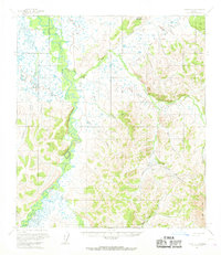
1954 Map of Ophir C-1
USGS Topo · Published 1965About this map
The Innoko River winds through this interior Alaska landscape, defining a wide, marshy corridor punctuated by small settlements and aviation outposts. During the mid-1950s, Cripple Landing served as a key point of access along the river, while further inland, the Bear Creek No 3 Landing Strip provided a vital link for remote operations. The terrain shifts from the low-lying river valley to the prominent Hunch Mountain and the Cripple Creek Mts in the southeast. Evidence of resource extraction is visible near Graham Creek, where a Mine is situated. Movement across the landscape is traced by a Winter Trail that bypasses the summer swamps, connecting the settlement of Folger to the surrounding network of drainages like Colorado Creek and Boston Creek. This survey captures the isolated infrastructure of the Yukon-Koyukuk region before more modern transportation networks were established.
Find a feature on this map
21 named features on this map. Tap any name to fly to it.
Don’t see what you’re looking for? This feature index may not catch every label — zoom into the map to look around manually.
Map Details
Editions of this 1954 Ophir C-1 Map
2 editions found
Other maps of this area

1950 · Medfra
USGS Topo · 1:250,000

1951 · Ophir
USGS Topo · 1:250,000

1954 · Medfra C-6
USGS Topo · 1:63,360

1954 · Medfra D-6
USGS Topo · 1:63,360

1954 · Medfra B-6
USGS Topo · 1:63,360
1954 · Ophir D-1
USGS Topo · 1:63,360

1954 · Ophir C-2
USGS Topo · 1:63,360

1954 · Ophir B-1
USGS Topo · 1:63,360

1954 · Ophir B-2
USGS Topo · 1:63,360
1954 · Ophir D-2
USGS Topo · 1:63,360