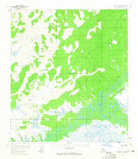
1954 Map of Ophir D-2
USGS Topo · Published 1965About this map
The Innoko River dominates this mid-1950s landscape, winding through a complex system of oxbow lakes and wetlands in the Alaskan interior. The river's serpentine path is mirrored by its major tributary, the North Fork, and the smaller Slow Creek, which cut through the lower elevations. While the majority of the terrain is characterized by these dense water networks and intermittent forest cover, the high ground is marked by prominent elevations such as Crown. Evidence of human presence is sparse but significant, with the settlement of Jones and a solitary Cabin situated near the edges of the river valley. This survey reflects the region during a period of photogrammetric mapping, capturing the exact state of the shifting waterways and identifying remote landmarks that served as vital navigation points in the Yukon-Koyukuk wilderness.
Find a feature on this map
8 named features on this map. Tap any name to fly to it.
Don’t see what you’re looking for? This feature index may not catch every label — zoom into the map to look around manually.
Map Details
Editions of this 1954 Ophir D-2 Map
This is the sole edition of this map. No revisions or reprints were ever made.
Other maps of this area

1945 · Nulato
USGS Topo · 1:250,000

1951 · Ophir
USGS Topo · 1:250,000

1951 · Nulato
USGS Topo · 1:250,000

1952 · Nulato A-2
USGS Topo · 1:63,360

1952 · Nulato A-3
USGS Topo · 1:63,360
1952 · Nulato A-1
USGS Topo · 1:63,360

1952 · Nulato
USGS Topo · 1:250,000
1954 · Ophir D-1
USGS Topo · 1:63,360

1954 · Ophir C-3
USGS Topo · 1:63,360

1954 · Ophir C-1
USGS Topo · 1:63,360