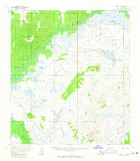
1954 Map of Ophir D-1
USGS Topo · Published 1965About this map
The Innoko River system dominates this Alaskan landscape, captured during a mid-1950s survey that reveals the intricate network of the West Fork Innoko River and its numerous tributaries. Navigability and overland travel in this remote region are defined by seasonal routes, such as the Winter Trail and a specialized Tractor Trail cutting through the interior. Notable elevations including Lone Jim Mountain and Hunch Mountain provide orientation in a territory largely comprised of marshy lowlands and winding waterways like Fourmile Creek and Elk Creek. A solitary Cabin stands as a rare sign of human habitation, indicating the sparse settlement patterns typical of the Yukon-Koyukuk region before more modern infrastructure arrived. This document provides a look at a landscape where land lines were still unsurveyed and unmarked, as noted by the Bureau of Land Management.
Find a feature on this map
11 named features on this map. Tap any name to fly to it.
Don’t see what you’re looking for? This feature index may not catch every label — zoom into the map to look around manually.
Map Details
Editions of this 1954 Ophir D-1 Map
2 editions found
Other maps of this area

1945 · Nulato
USGS Topo · 1:250,000

1950 · Medfra
USGS Topo · 1:250,000

1951 · Ophir
USGS Topo · 1:250,000

1951 · Nulato
USGS Topo · 1:250,000

1951 · Ruby
USGS Topo · 1:250,000

1952 · Nulato A-2
USGS Topo · 1:63,360

1952 · Ruby A-6
USGS Topo · 1:63,360
1952 · Nulato A-1
USGS Topo · 1:63,360

1952 · Nulato
USGS Topo · 1:250,000

1952 · Ruby
USGS Topo · 1:250,000