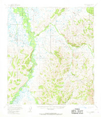
1954 Map of Ophir C-1
USGS Topo · Published 1968About this map
The Innoko River snakes through this remote Alaskan interior landscape, defining a complex network of wetlands and tributary drainages during the mid-1950s. This survey records a vital moment in subarctic transport, where seasonal movement relied on the Winter Trail and Summer Trail corridors that connected isolated outposts. Small-scale aviation and river access supported the few established points of human activity, most notably at Cripple Landing along the riverbank and the settlement of Folger.
Find a feature on this map
21 named features on this map. Tap any name to fly to it.
Don’t see what you’re looking for? This feature index may not catch every label — zoom into the map to look around manually.
Map Details
Editions of this 1954 Ophir C-1 Map
2 editions found
Other maps of this area

1950 · Medfra
USGS Topo · 1:250,000

1951 · Ophir
USGS Topo · 1:250,000

1954 · Medfra C-6
USGS Topo · 1:63,360

1954 · Medfra D-6
USGS Topo · 1:63,360

1954 · Medfra B-6
USGS Topo · 1:63,360
1954 · Ophir D-1
USGS Topo · 1:63,360

1954 · Ophir C-1
USGS Topo · 1:63,360

1954 · Ophir C-2
USGS Topo · 1:63,360

1954 · Ophir B-1
USGS Topo · 1:63,360

1954 · Ophir B-2
USGS Topo · 1:63,360