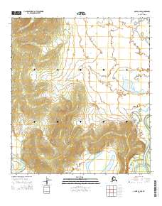
2015 Map of Ophir C-4 NW
USGS Topo · Published 2015About this map
Innoko River meanders through the southeastern portion of this landscape, carving deep oxbow loops across the terrain. This interior region of Alaska, documented by the U.S. Geological Survey in 2015, is characterized by its complex hydrography and shifting river channels. In the northeastern corner, the Mud River flows into the quadrangle, highlighting the water-dependent geography that historically governed transport and survival in the Yukon-Koyukuk region. The absence of road infrastructure or named settlements on this sheet reflects the remote nature of the territory, where the river systems remain the primary geographic anchors for navigation and land use.
Find a feature on this map
8 named features on this map. Tap any name to fly to it.
Don’t see what you’re looking for? This feature index may not catch every label — zoom into the map to look around manually.
Map Details
Editions of this 2015 Ophir C-4 NW Map
This is the sole edition of this map. No revisions or reprints were ever made.
Other maps of this area

1951 · Ophir
USGS Topo · 1:250,000
1954 · Ophir D-4
USGS Topo · 1:63,360
1954 · Ophir D-5
USGS Topo · 1:63,360

1954 · Ophir C-5
USGS Topo · 1:63,360

1954 · Ophir C-4
USGS Topo · 1:63,360

1954 · Ophir
USGS Topo · 1:250,000
2015 · Ophir C-4 SW
USGS Topo · 1:25,000
2015 · Ophir C-4 SE
USGS Topo · 1:25,000
2015 · Ophir C-5 NE
USGS Topo · 1:25,000
2015 · Ophir C-5 SE
USGS Topo · 1:25,000